 The Independent Uganda: You get the Truth we Pay the Price


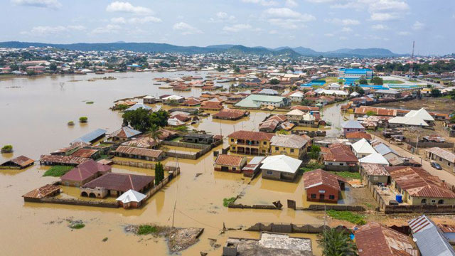
Nigeria has had a flood crisis since June 2022, with a resounding impact — over 600 lives lost, almost 1.5 million displaced, and over 200,000 homes damaged in 370 local governments across the country’s 36 states. This is the country’s worst flood incident in a decade, with floods projected to continue until end of November.
Lagos, Nigeria | BIRD AGENCY | In its seasonal climate prediction for 2022, the Nigerian Meteorological Agency (NiMet) predicted an average annual rainfall range of 390 mm in the far north to 2790 mm in the coastal states. This forecast is similar to 2021.
The coastal states, located in the southern and middle-belt regions of Nigeria, are generally prone to seasonal flooding due to prolonged rainfall and their location along Rivers Niger and Benue. The rainy season in some coastal states begins as early as February and ends in mid-December.
The floods have mainly affected the twelve Nigerian states along the Rivers Niger and Benue. These states are spread across four geopolitical regions — south-south, south-east, north-central and north-east — and include Bayelsa, Edo, Rivers, Anambra, Kwara, Kogi, Niger, Benue, Nassarawa, Taraba, Plateau and Adamawa.
Recent data released by the Federal Ministry of Humanitarian Affairs, Disaster Management and Social Development as of October 28 shows that at least one local government in all 36 states and the Federal Capital Territory (FCT) have experienced flooding.
“In the beginning, we thought the flood would be just like the previous years,” said Samuel Uduma, a resident of Lokoja, Kogi state. Uduma helps his father in his clothing store at the New Market and occasionally purchases supplies at a market in the central part of town.
The floods disrupted his market trips. He now had to rely on canoes to purchase goods, and the transportation fare increased each time he made the trip. At one point, it rose to 600 Nigerian Naira ($0.82) — more than double the pre-flood cost.
The town’s major highway, an important link between the southern and northern parts of the country, was completely inundated, leaving travellers stranded.
“This is the highest floodwater we have ever seen; we never had to use canoes in 2012,” says his father, Uduma Okwara.
At the peak of the flooding in Lokoja, the river embankment built along the shores of the River Niger was submerged entirely, and flood water spread into the surrounding communities.
The four-kilometre embankment was a 2015 project by the Kogi State Government developed as a precautionary measure to mitigate flooding when the River Niger overflows its bank. It was a response to the 2012 flood that badly affected the state.
The government has attributed the flooding to heavy rainfall and climate change. “80 per cent of the floods in this country is water that we are blessed with God from the sky,” said Suleiman Adamu, the Nigerian Minister of Water Resources.
While it is true that extreme rainfall contributed to the ongoing floods, there is no evidence to support the figure the minister claimed.
What caused the 2022 floods?
In the past three years, floods have become the second most recurrent hazard affecting Nigeria after epidemics, with flood events peaking around August and October.
The damage caused by the 2022 floods is greater than any single flood event recorded in the country; it can only be compared to the 2012 floods.
According to the Nigerian Inland Waterway Authority (NIWA), as of October 6, 2022, water levels stood at 13.22 metres (43 feet), 0.38 metres higher than the 12.84 (42 feet) metres recorded in 2012. Both measurements were taken within a month after Cameroon released water from its dam.
Geospatial data and satellite images gathered by Sentinel Hub show that the current flood events across the country resulted from abnormally heavy rainfall exacerbated by excess water from Cameroon’s Lagdo dam.
Cameroon’s Dam
In September, Cameroon’s power company, Eneo announced plans to release excess water from the Lagdo dam after its reservoir hit 91% capacity — water have to be released frequently to prevent overspilling.
“The Lagdo dam operators in the Republic of Cameroon have commenced the release of excess water from the reservoir by September 13, 2022. We are aware that the released water cascades down to Nigeria through River Benue and its tributaries, thereby inundating communities that have already been impacted by heavy precipitation,” The National Emergency Management Agency (NEMA) revealed in a statement on September 19.
The Lagdo dam — located 100km from the Nigerian border — empties its excess water into the River Benue. However, the absence of a buffer dam and adequate flood control measures limits the ability of the Nigerian authorities to avert the impact of the higher-velocity air water arriving in its territories.
At the inception of Cameroon’s Lagdo Dam in 1977, Nigeria signed an agreement with Cameroon to build a buffer dam — named Dasin Hausa Dam — to cushion the effect of the water released from the Lagdo Dam. Forty-five years after committing to the project, the Nigerian government has yet to fulfil its side of the contract and has resorted to makeshift measures to help flood victims.
A satellite image taken on October 22 shows that the dam water aggravated the expansion of the River Benue. Subsequently, the river overflowed into Numan, a port town in Adamawa State, Northeast Nigeria.
Climate Change
Between 2011 and 2020, Nigeria recorded 103 flood events, most of which were linked to intense rainfall, according to a 2022 review by Nura Umar, a lecturer of the Department and Statistics at the Umaru Musa Yar’adua University in Katsina State. The study, like many others, links these abnormal rainfall patterns to climate change — this also holds true for the ongoing flood events across the country.
Satellite images taken a few days before the release of water from the Lagdo dam showed that both rivers — River Benue and River Niger — had already expanded due to heavy rainfall.
Since June, certain areas in southern Nigeria have experienced rainfall amounts of over 100 mm daily. The northern regions have also experienced higher-than-normal rainfall. In August, NiMet reported that most of the states in this region had recorded over 300 mm of rain, 25 per cent above the monthly normal.
NiMet’s monthly flood analysis published before water was released from the dam showed that the soil moisture content had already attained saturation levels due to accumulated rainfall across the country.
This means that many of the states currently experiencing floods were already vulnerable.
In summary, severe rainfall is responsible for most floods across the country, with the dam water worsening the impact of months of heavy precipitation.
What is at stake?
The impact of the flood events is far-reaching, even worse than the 2012 floods that led to an estimated loss of $17 billion.
As of September 2022, inflation in Nigeria reached its highest in 17 years, and the impact of the flood could cause further strain on the economy.
The total financial loss caused by the ongoing floods is yet to be ascertained. However, the country has incurred significant losses across some of its dominant sectors, including agriculture, health and energy.
Agriculture
The World Food Programme reported that over 630,000 hectares of farmland had been destroyed since the floods began in June 2022.
This includes 4,500 hectares of Olam’s rice farm worth over $15 million swept away when the floods hit Nassarawa State. The Olam Rice Farm is Nigeria’s biggest contributor to the rice value chain.
The State Emergency Management Agency (SEMA) in n Adamawa reported that the floods swept away over 89,000 hectares of farmland.
Before the floods, Nigeria faced food insecurity resulting from inter-communal conflicts. The increased food shortage and inflation place the country at high risk of a major food crisis.
Health
In Agbere, a rural community in Bayelsa State, the floods have inundated the only primary healthcare centre (PHC) serving the residents and providing maternal care.
“The doctors, pharmacists … everyone in the hospital has left and no one knows when they will return,” says Paul Neche, a staff of the PHC.
Preliminary data from the United Nations Satellite Centre (UNOSAT) show that 1,370 health facilities are either flooded or close to a flooded zone.
For a region like Nigeria, prone to infectious diseases, losing health infrastructures is a massive blow to the country’s fragile public health system.
In addition, contaminated water and other unsanitary conditions associated with floods have increased the risk of further disease outbreaks.
Currently, there is a cholera outbreak in the northeastern region, and more than 7,700 cases have already been reported.
Energy
On October 17, 2022, Reuters reported that the Nigeria Liquefied Natural Gas (NLNG) company had declared force majeure.
This was linked to high floodwater levels in the company’s operational areas that significantly impaired gas production and upstream supply.
NLNG supplies 40% of Nigeria’s cooking gas, and impaired supply could lead to price inflation. Residents in oil-rich Bayelsa confirm that this is already happening.
“One kilogramme of cooking gas was formerly sold for 900 naira, but its current price is 2000 naira,” said Sunday Ebele, a member of the national youth service corps in Bayelsa State.
This negatively affects Nigeria’s plans to promote local gas utilisation as part of its strategy to reduce uncontrolled gas flaring in the environment. Gas flaring is Nigeria’s largest single source of greenhouse gases, contributing nearly 55 million tonnes of CO2 annually.
As a critical player in the global LNG business, NLNG is a significant contributor to Nigeria’s foreign exchange reserves. Since its inception in 1999, the company has remitted $18 billion in dividends and $9 billion in taxes to the Nigerian government.
Response
About a month after the Lagdo dam was opened, the Federal Executive Council approved the National Flood Emergency Preparedness and Response Plan for Nigeria.
The specific details of the response plan are yet to be made public, but it is reported to contain immediate, short-term and long-term measures to control flooding in the country.
However, the government has repeatedly come under criticism for its failure to implement sustainable flood control measures even though they have systems that can detect extreme weather events early.
The government has yet to develop better city plans to manage the growing population and prevent settlement on flood plains.
Located 200 km from the Lagdo dam and 1,000 km away from the badly flooded Kogi State, the proposed Dasin Hausa dam is well-placed to mitigate the flood impact on the state and the other surrounding states in Northeastern Nigeria.
The abandoned dam — more than twice the size of the Lagdo dam — was also supposed to generate 300 megawatts of electricity and provide irrigation support to about 150,000 hectares of land in Adamawa, Taraba, and Benue states.
In an interview with Al Jazeera, Adamu — Nigeria’s Minister of Water Resources — revealed that feasibility studies have already been completed for the Dasin Hausa dam. However, he did not comment on the project timeline.
Based on the seasonal climate prediction, heavy rainfall is expected to continue until November — mid-December for some southern states. This invariably means an increased risk of flooding in more communities.
Past and recent flood events have shown the country’s short-lived reactive measures to flood disasters are inefficient. To salvage the economy, environmental activists have advised that the government commit to climate financing and adopt sustainable flood control measures that suit its current ecological needs.
******
SOURCE: bird story agency