 The Independent Uganda: You get the Truth we Pay the Price


Why experts now want KCCA to cope with, not fight rain
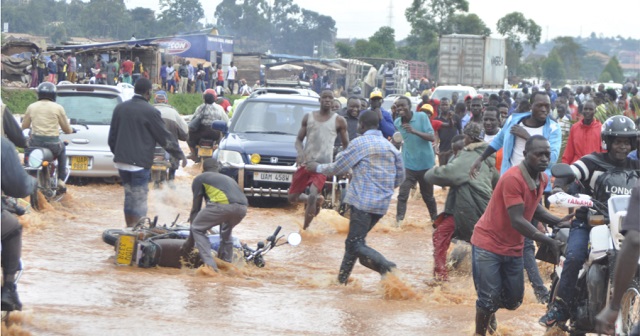
Kampala, Uganda | RONALD MUSOKE | For hundreds of thousands of Kampala residents, the onset of the rain season these days means suffering, losing property and even lives and this year’s rainy season has not been any different.
There is always apprehension and fear when dark rain clouds twirl above the city and its suburbs. Commotion ensues as matatu taxis and bodaboda cyclists and pedestrians hurry past known flood spots.
Many without better alternatives jostle for shelter to escape the looming downpour. Raindrops quickly turn into tropical showers within minutes and transform into a full-blown rainstorm triggering floods. Roads become rivers. Unlucky victims caught in its way become another statistic of flood deaths.
This year, the floods have been particularly devastating. On May 26 eight people were killed in a storm. Property valued in billions was destroyed.
In one photograph which went viral on social media, a chicken farmer tried to save hundreds of his chickens by climbing on the rooftop of his house with them. The farmer later identified as Richard Kanyike, 63, a resident of Lufuka zone in Bunamwaya said he lost over 300 chickens to the floods. He described how the water, which kept swelling until it rose to the window level of his chicken house, overwhelmed him.
Kampala sits on the northern shores of Lake Victoria, the world’s largest tropical lake which contributes a lot of the rainfall the city receives throughout the year. It is a city of wetlands; Lufuka, Kansanga, and Nakivubo wetlands in its southeasterly division of Makindye. Mayanja, Lubigi, Nabisasiro, Nasere in Kawempe division, and Nakalere, Nalubaga, Walufumbe and Kinawataka in Nakawa Division. These are the main ones. But almost every part of the city has its own wet pan where storm water gathers to wreak havoc.
This year, so far, it is the Kikajjo, Lubowa and Lufuka areas that have been hardest hit. They are in the Kyetinda flood area; a basin estimated to be about 1.4 square kilometres between Lufuka and Kansanga wetlands. Without floods, these would be prime real estate as it is between the Kampala-Entebbe highway and the Lake Victoria hind end zone of top beaches and hotels; include the Munyonyo Commonwealth Resort.
But the plight of residents is now a result of a mix of the same things that make other areas flood prone. Stated plainly, nobody should be living in these areas because they lie directly in the path of storm waters from higher lying areas of Makindye, Nsambya, Buziga, and more.
In the past, the storm water could flow smoothly into Lake Victoria through the Munyonyo wetlands. Today, as the city population has swollen to over 1.8 million, construction pressure has blocked most of the natural water drainage routes and no drainage channels have been constructed to replace them. The result is that even the least amount of rain now causes floods.
Godfrey Mujuni, the manager Data Centre at the Uganda National Meteorological Authority told The Independent on June 13 that most of the rain the city receives is moderate when compared to other flood-prone cities around the world. It should not be causing deadly floods.
Mujuni said, for example, although Kampala received a lot of rain over the month of May, the rains do not differ in significance when compared to past seasons.
“What we have noticed is the intensity,” Mujuni told The Independent. “A lot of rain falling these days occurs in a shorter period of time.”
He said the limited drainage channels fail to cope with the run-off which is too much in a short period.
Mujuni told The Independent that it is in the second Dekad—period of 10 days— (May 10-20) that Kampala received the most rain. It rained on eight out of the ten days.
On May 11, Kampala recorded 37.5mm of rainfall. The following day, May 12, the weather experts recorded 22.8mm, on May 13, they recorded a trace (drizzle); on May 14, they recorded 18.8mm, while over the next five days, UNMA recorded 2.5mm, 2.8mm, 3.5mm, 21.3mm and 7.8mm, respectively.
Mujuni says rains become hazardous when an area registers above 50mm. So what has been happening in Kampala where the weather experts have been registering rains of below 40mm?
Mujuni says rains measuring 37.5mm would not normally cause havoc, especially if the rain is spread over a long period— say over 24-hours. But, if the same rains fall for just one hour, these could create havoc because of intensity.
On the deadly May 26, the day the floods caused havoc, the meteorology department registered just 2mm of rainfall over Kampala. But the previous day, more rain (19.1mm) had fallen over the city, and the day before that, another 8.2mm of rainfall had been registered. So the rains which fell on May 26 soaked the ground until it could take no more.
Collins Oloya, the commissioner for wetlands management in the Ministry of Water and Environment says the floods ravaging Kampala are as a result of the continuous disregard of the environmental laws.
Oloya told The Independent that the people who planned Kampala originally built it on seven hills because they appreciated the function of the wetlands but these have been completely destroyed.
“Now KCCA needs a lot of money to control floods—a function which was being done by wetlands at a much low cost.”
Big budget needed
On April 4, KCCA’s top executives presented a budget of US$208 million (over Shs700 billion) to implement a 2017 drainage master plan that intends to fix 10 flood-prone areas in Kampala including; Lubigi, Nakivubo, Kinawataka, Kansanga, Nalukolongo, Ggaba, Walufumbe, and Mayanja.
KCCA’s drainage master plan seeks to control storm water by encouraging rain water harvesting, creating “rain gardens,” green parks and open gardens, detention ponds, retention basins and associated wetlands.
In some of KCCA’s planned drainage projects, the Lubigi Channel which stretches a distance of about 3km from Bwaise to Hoima Road will be expanded again in some sections to about 40 metres while in other sections it will be as wide as 100 metres.
The Lubigi Channel is one of Kampala city’s major channels that evacuate storm water out of the city when it rains. It forms an arc around the city, starting around Kisaasi in the north of thecity and then stretches westwards passing Bwaise and Kawaala, then turns southwards through Busega.
The channel has feeder arms that stretch along the Kampala–Mityana Road towards Buloba, along Kampala–Masaka Road towards Kyengera, along Kampala-Hoima Road towards Nansana and along the Mengo-Sentema stretch.
KCCA officials say the new drainage master plan intends to integrate the natural environment and infrastructure into a cohesive city-wide strategy for drainage development that minimizes the impact of flooding. But some experts argue that KCCA’s planned intervention will once again prove inadequate.
Bashir Twesigye, the executive director of Civic Response on Environment and Development (CRED), a Kampala-based non-profit told The Independent that the biggest challenge in Kampala is human encroachment on environmental resources like swamps that needs to be fixed.
Other experts also say Kampala’s persistent floods are a result of inadequate sensitization of the public, unplanned settlements and poor enforcement mechanisms and the mindset of the residents who continue to arbitrarily litter garbage.