 The Independent Uganda: You get the Truth we Pay the Price


Kampala, Uganda | THE INDEPENDENT | Douglas Mutumba, a resident of Namugongo in Wakiso district is a very unhappy over the sudden loss of a significant section of his three-acre piece of land. Mutumba says the problem began in June this year when a survey firm visited the land to subdivide it for him.
He says the firm reported seeing only 48 meters of the original 73-meter length enclosing the northern flank of his beloved property. Even when visible on the title Mutumba holds in his hands, he insists that the full length was not visible on the ground.
To prove his point, Mutumba collected his neighbors’ land titles for the survey firm to trace where his unseen land migrated to. Six months down the road, the outcome of the search is yet to be released.
Mutumba isn’t alone. Similar complaints have been reported in other parts of the country, where people find the coordinates of their land in their neighbor’s plot.
Dr. Ronald Ssengendo, the President of the Institution of Surveyors of Uganda, an umbrella network for Professional Surveyors, says Mutumba’s situation stems from a fundamental problem they discovered with Uganda’s Geodetic Reference Frame (UGRF), the backbone of land survey in the country.
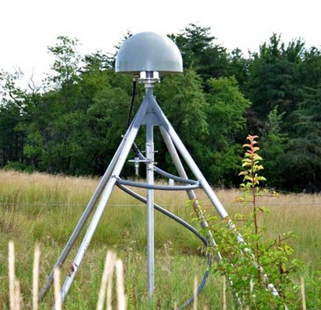
Dr. Ssengendo says construction of the original Uganda’s Geodetic Reference Frame, made up of Concrete pillars, which are visible to the naked eyes above the ground, was completed in the 1960s.
He says in the 1970s, opportunists seeking wealth destroyed most of the reference points making up the Frame in search of Mercury underneath their pillars for sale, leaving just a few on the ground around the country.
Dr. Ssengendo says what this means is that those conducting land surveys cannot easily find a reference point in some areas resulting into overlap of boundaries in such areas.
In Urban centers, the Coordinates were destroyed by Infrastructural development. Some new Stations have been installed in traditional towns of Fort portal, Entebbe, Kampala, Lira, Gulu, Mbale, Soroti, Masindi, Arua and Gulu among others in tightly guarded government institutions.
Rittah Nakasawe, The Programme Development Officer of the Institution of Surveyors of Uganda, says to correct the overlapping boundaries like those of Mutumba will require a resurvey of all plots in the area for their boundaries to be re-drawn using the rebuilt Geodetic Reference Frame.
The Institution says they have since joined efforts with government to rebuild the damaged Uganda Geodetic Reference Frame by installing new Global Positioning Machines (GPS) around the Country. The Machines are being installed under a five-year project funded by the World Bank.
By December this year, some modernized 426 GPS Reference Points had been installed in Permanent Stations located in government institutions around the country alongside some 12 Continuous operation reference stations (CORS).
Dr. Ssengendo says the other causes of overlapping land boundaries include infiltration of the Land Survey profession by unskilled land brokers, fraud and the use of un-calibrated equipment. “The biggest challenge is the demolition of the Geodetic Reference Frame. The others are secondary although majority of the overlapping surveys are caused by trained surveyors who are yet to gain sufficient experience and the non-surveyors” he told Uganda Radio Network.
Traditionally, Land Survey was a complex job for Surveyors. Dr. Ssengendo says the emergence of hi-tech technologies have fairly simplified the job. He described how Surveyors determine land boundaries using the newly installed stations around the country.
Fraud in Land Survey constituted the bulk of complaints handled by the just concluded Justice Catherine Bamugemereire led Land Commission of Inquiry. The Commission says it unraveled an intricate collusion to dispossess the poor of their land.
*******
URN