Restoration efforts
In 2010, leaders of the districts which share the lake signed an agreement to protect its buffer zones. However, the locals violated it and encroachment continued. It now appears another effort to save the lake is on.
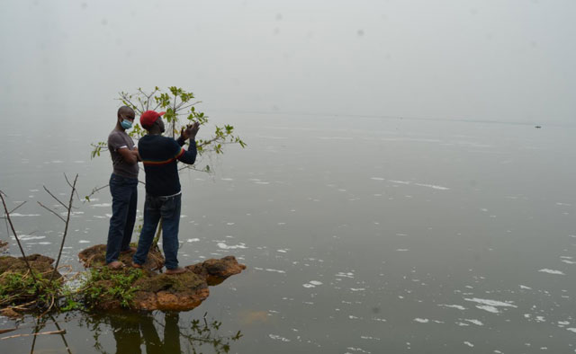
Yasin Bbira, the Natural Resources Officer for Mityana, told The Independent that Mityana wants to clearly demarcate the wetland boundaries so that even when water levels and wetland vegetation coverage recede, the communities are clear on where the boundaries lie.
“We have tried to demarcate the wetlands which drain into Lake Wamala, because this lake is like a basin. It depends on both rain water but also on water from the rivers which drain into the lake.”
Lake Wamala has several rivers draining into it, including River Wabiluko near Mityana, River Nyanzi, River Mpamujugu, River Tyabiira, River Bimbye, River Kaabasuma and River Kibimba. River Kibimba connects to the bigger River Katonga, which then empties into Lake Victoria.
Bbira says this should ensure the lake gets enough water for its survival. He mentions wetlands near tributaries of rivers like Nakatongoli, Mpamujugu, Wakitundu, Nyanzi and Kaabasuma—which have been restored.
“We have evicted encroachers on the lake’s buffer zones to reduce pressure on fish capture, because we also enforce the law on fishing. We confiscate illegal fishing gear and arrest culprits and charge them in courts of law. But, we have also demarcated the fish breeding zones,” he says.
He says the fishermen together with the authorities have identified breeding zones such as those around Gombe landing site where no fishing is allowed. He says together with the Lake Victoria Management Project (LVEMP), a project funded by the World Bank to save Lake Victoria by protecting satellite lakes like Wamala, they are putting markers to show fishermen where they are not supposed to fish.
Bbira says the project tried to give alternative livelihoods, such as poultry rearing, to fishermen to stop them from cultivating on the shores and wetlands. To reduce pollution of the lake, the LVEMP project built latrines and improved sanitation facilities at several landing sites. Farmers around Katiko landing site have also constructed soil bands (boundaries) to reduce siltation of the lake.
They have planted orange trees on some shores and introduced rainwater harvesting tanks to control soil erosion and siltation of the lake. In Bukanagga, the Orange Growers Association has installed underground water harvesting tanks for irrigation purposes.
Richard Kimbowa, the Programme Manager of the Uganda Coalition for Sustainable Development (UCSD), who has been doing conservation research around Lake Wamala since 2005, says programmes like the LVEMP have not had a substantial effect on the lake’s fortunes.
Kimbowa says the districts that share Lake Wamala should develop an integrated management plan to offset some of the current challenges the lake is grappling with. But, he says, the best bet for rescuing Lake Wamala would be declaring it a Ramsar Site or a wetland of international importance.
Kimbowa says as a Ramsar site, the lake and its numerous cultural sites would be put on a cultural tourism circuit and improve conservation of its cultural heritage and biodiversity.


Kimbowa says, for example, the lake is home to three critically endangered fish species—the lung fish, cat fish and mud fish. Meanwhile the Baganda, the indigenous tribe that lives around the lake’s shores also believe that some of the islands are a home to important ancestral spirits.
“Therefore, the lake is of such ecological and cultural importance,” he says, “Having it as a Ramsar Site would help conservationists garner international support in terms of research and financial resources.
“It would then be easier to work with a common vision and objective and the lake would benefit from management plans that these Ramsar Sites get.”
This plan, he says, was first mooted during the World Wetland Day celebrations, which took place on the lake’s shores in 2015. But, he told The Independent that the process has been painfully slow.
But, Dr. Tom Okurut, the executive director of the National Environment Management Authority (NEMA), says designating the Lake Wamala catchment as a Ramsar Site will not work because it is not in the Ugandan law.
Rather, Okurut told The Independent that the government is considering designating the catchment area as a “special conservation area” to prohibit certain activities.
Kimbowa is unimpressed by the NEMA boss’ suggestion. He insists this would be a downgrade of the Lake Wamala catchment status. Kimbowa says Lake Wamala at the moment is like a patient on a drip in hospital.
“We can still resuscitate it,” he says.
“The situation of the lake is too bad. I wouldn’t hide behind the law. I would prefer designating it as a Ramsar Site. The more the catchment attracts international attention, the better.”
If nothing major is done to save Lake Wamala, conservationists say the lake could dry up due to its piling pressures. If that happens, it will not be the first time the lake has shrunk or almost disappeared.
In the 1990s, Ssenyonjo, the fisheries officer, says Lake Wamala dried up and nearly disappeared.
“People even parceled up plots and started cultivating in the middle of the lake zone,” Ssenyonjo told The Independent. But that was only for a short time before nature, in the form of the El Niño rains of the late 1990s, hit back and sent the encroachers scuttling.
Those rains widened the lake to almost its 1960s size when Lake Wamala covered almost 250 sq km with a wetland zone of 60 sq km and a maximum depth of 4.5 metres.
The NaFIRRI has satellite images taken by the UN Environment Programme (UNEP), which show that the lake shrunk to half its size between 1984 and 1995 and increased between 1999 and 2008. It never regained its original size.
According to the scientists, the lake is once again shrinking and the encroachers are returning. But as Tebajanga said, Lake Wamala, knows how to protect itself and in the years to come, with another El Niño, it will surely reclaim its boundaries.
****
Credit: This story has been produced in partnership with InfoNile with support from Code for Africa and funding from the JRS Biodiversity Foundation.
 The Independent Uganda: You get the Truth we Pay the Price


Free porno adult free web cams porno free porno chat