 The Independent Uganda: You get the Truth we Pay the Price


Why Speke was surprised by River Katonga 160 years ago, and its implications now
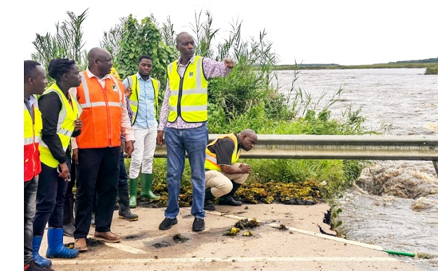
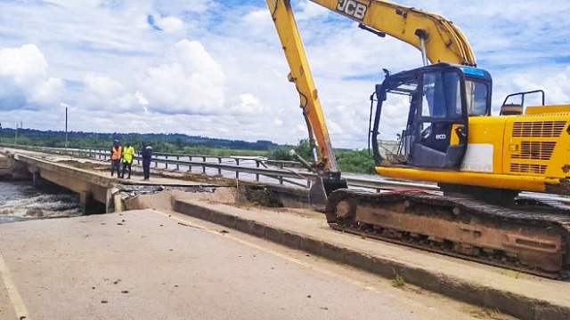
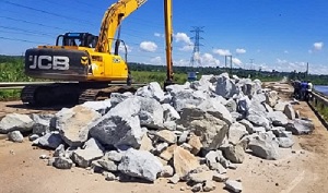
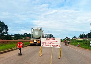
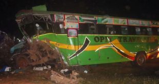
COVER STORY | RONALD MUSOKE | The roads and bridges unit from the Uganda National Roads Authority (UNRA) will over the next three weeks attempt to restore the bridge over River Katonga that collapsed on May 11 following the bursting of the river banks.
Located approximately 80km west of Kampala, the bridge on River Katonga is part of the main gateway to the southwestern parts of the country and links Uganda to the eastern Africa hinterland including Rwanda, Burundi, eastern DR Congo and the northern parts of Tanzania.
The damaged section of the bridge is now a no-go area and a roadblock has been mounted by the Uganda Police Force just 2km before the bridge. At the moment, thousands of motorists who use this road can only take a detour at Mpigi and drive for about 185km through the 137km Kanoni-Sembabule road and the 47km Sembabule-Masaka section to reach Masaka City and beyond. There is also another route along the Kyabakuza-Mateete road along Kyogya Swamp and the Villamaria-Kabulasoke road located upstream of this river which connects to Kampala-Masaka Road.
“In the short term, we intend to restore this section and open it to the public over the next three weeks,” Allan Ssempebwa Kyobe, the UNRA spokesperson told The Independent on May 15. “In the long term, if we get finance, the solution is to raise the profile of that road, put a bigger drainage structure like box culverts.”
“These will be able to allow all the huge volumes of water to be channeled through. And this is just for Katonga. We hope to fix other problematic sections of this road around Lwera and Kalandazi area.”
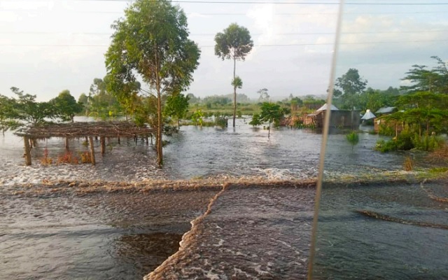
But, as emergency works continue to reinstate this bridge, questions are being asked about how a road which was fixed just 10 years ago easily collapsed. Some Ugandans have wondered if indeed UNRA considers climate change during its road designs.
However, Ssempebwa, the UNRA spokesperson told The Independent that “everything required to be done before a road infrastructure project takes off was done on this road.”
“Before UNRA undertakes any construction, the agency does all the necessary studies on the environment and carries out social and environmental impact assessments. So, everything was done on this road by the contractor, RCC,” he said.
“We attribute the bridge collapse to the changing weather patterns; the water levels are increasing in Lake Victoria and when it rains, the way it is raining lately, floods are triggered and when these floods find a low-lying road like this section is, it is easily compromised.”
He added: “The existing natural drainage systems have also been weakened because of increasing settlements in wetlands. The water no longer has its original catchment points so it struggles to move and finds itself on the road surface.”
John Speke and his River Katonga experience
However, a section of Ugandans says the Katonga-wetland system which includes this river has always been a problem for the natives who inhabit its environs.
In fact, British explorer, John Hanning Speke, documented River Katonga’s behaviour in his memoir he published in the Journal of the Royal Geographical Society in 1863 following his successful odyssey of the East African hinterland that led him to the discovery of the Source of the River Nile in Uganda.
In the memoir titled, “The Upper Basin of the Nile: From Inspection and Information,” Speke said: “I crossed the Katonga rush-drain, which debouches on the Equator and then I entered Uganda Proper. The Katonga (wetland) was the largest rush-drain I had as yet crossed, or rather it was a network of drains confined in a valley about four miles (6.4km) broad.”
He added: “It happened to be fordable everywhere just at this time, though the natives say it sometimes swells in certain parts to the height of a man, and therefore cannot be crossed on foot.” Interestingly, Speke noted that the Baganda natives had told him that River Katonga usually swells when the least rain falls.
It appears River Katonga was a headache for the colonial government and it continued to feature in the government’s annual reports, possibly as they attempted to find a permanent solution to the challenging terrain round it.
Damming River Katonga
According to a 1947 British colonial government report on Uganda’s inland waterways which is available online, there was a suggestion that the then government build a canal in this part of the Katonga wetland system right from the point where River Mpanga joins Katonga to Lake Victoria.
For purposes of arriving at an estimated cost of this proposal, an organization was set up towards the end of 1947 to undertake detailed survey work essential to the design and planning of the proposed canalization project which would consist of 124 miles (about 200km) of navigable waterway from Katonga Bay near Katebo port to a point one mile east of the confluence (meeting point of the Mpanga and Katonga Rivers).
By the end of 1949, all the fieldwork, including the study of the hydrology of the River Mpanga catchment area had been completed and the project report was in preparation. However, it is not clear why the colonial government eventually shelved the idea. What is unmistakable is that it would probably have gone a long way in finding a long-lasting solution to the flooding around River Katonga.
Can the current Govt find a permanent solution for Katonga?
According to a statement issued by the Ministry of Water and Environment on May 13, it has launched an investigation into the recent flooding of the River Katonga Bridge.
“As of May 12, the water level at all the sections of Katonga system from upstream to downstream had greatly receded measuring 5.3 metres at Katonga Bridge,” the Ministry said in a statement posted on one of its social media platforms.
The ministry noted that inspections upstream of River Katonga have revealed a “dam breach” along the 4km stretch of the Kalungu-Gomba Road in Bugomola village, Rwabenge sub-county in Kalungu District. Local people here told ministry official how water had progressively built up on one side of the road due to the blocked culvert creating a damming effect.
The rising water level is said to have created massive force beyond the design capacity of the road creating a dam breach which led to a sudden release of large volumes of water creating a flood wave that moved downstream of River Katonga.
“The technical team will conduct a comprehensive study of the river’s hydraulics and hydrology considering rainfall patterns and water flow rates. The findings of the investigation will be used to develop strategies to prevent similar incidents from occurring in future,” the Ministry of Water and Environment said in a statement on May 13.
“We recognize the importance of maintaining vital infrastructure such as the River Katonga Bridge and will continue to work diligently with other relevant Government agencies including UNRA and NEMA to protect it from natural disasters such as flooding.”
But some independent environmental experts told The Independent that it may not be easy to find along lasting solution to the River Katonga flooding challenge.
Factories and farm land encroaching on wetland
The Katonga wetland is part of the Katonga catchment system that spans an estimated area of 13,837 sq km. It covers the districts of Wakiso, Mpigi, Butambala, Bukomansimbi, Kalungu, Gomba, Masaka, Lyantonde, Mityana, Mubende, Sembabule, Kiruhura, Kyegegwa, Kyenjojo, Kyotera and Kamwenge.
What is clear, experts say, is that this part of the country is a massive marshland. Right from Busega in Kampala where the Kampala-Masaka Road begins up to Masaka City, there are more than half a dozen expansive wetlands.
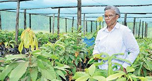
On the edges of some of these wetlands, factories are sprouting out. In Lwera, one of the biggest sections of wetland along this route, was converted into a commercial rice growing operation run by Chinese investors.
Richard Kimbowa, the programme manager of the Uganda Coalition of Sustainable Development, a regional environmental non-profit that supports the global response to the threat of climate change, told The Independent on May 15 that the occurrences on River Katonga on May 11 is just an example of what all rivers in the country are likely to do in the near future.
He attributes the challenge to encroachment upon the river banks by not only big factories but also small farms. “Of course, we cannot rule out the impact of climate change because in this same period, we have seen climatic impacts in Rwanda, DR Congo and other parts of Uganda (but) human influence is also there.”
“The likelihood of the massive encroachment of the Lwera wetland cannot be ruled out,” Kimbowa told The Independent, referring to the massive mat of wetland cover that has in recent years been given to a Chinese investor to grow rice. “The erosion of the catchment areas of these rivers has led to what you are seeing. This is just a symptom of what all rivers are facing.”
About three years ago, Dr. Apollo Buregeya from Makerere University’s Department of Civil and Environmental Engineering had given some counsel on the Katonga wetland system. He sounded an early warning of the flooded Katonga-Lwera stretch that often cuts off the Kampala-Masaka highway.
In an article that was widely shared on social media in the aftermath of the Katonga Bridge collapse, Dr. Buregeya enumerated the importance of the marshlands of Katonga-Lwera and Masaka on the stability of Lake Victoria’s water level. He advised President Museveni not to give away the marshlands to commercial rice farmers.
“Wetlands are regulators of Lake Victoria’s water levels,” he said, “They also work like the kidneys of the lake system. When you give away these marshlands for rice farming, you shift the equilibrium of both the water quality and the water levels of the lake,” he said.
“Please stop the rice farms at Lwera. It does not matter what your experts at NEMA tell you. They are not good custodians. It is the illegal sand mining and rice cultivation in the area that has altered the water catchment.”
Reacting to the shocking Katonga Bridge flood event, Dr. Oweyegha Afunaduula, a retired professor of ecology posted on his Facebook page arguing that unless the government addresses the ecological and environmental threats facing the country meaningfully and effectively, incidents like the one of Katonga will keep reoccurring.
“We should not be reactionary to hoodwink the people and communities that we are doing something about the calamities and losses they are suffering,” he said, “We must put people, ecology and the environment at the centre of strategies, policies and actions. The threats people are facing are not a matter of politics but survival. We must survive well in the future.”
“If we ignore ecology and the environment and think and believe that when nature takes its course, or invest money in small projects such as tree planting (which to date involves planting foreign tree species) we shall only be continuing to undermine our ecological and environmental security which we cannot ensure by accumulating arsenals of destructive weapons.”
Prof. Afunaduula noted, “We cannot be advocates or agents of ecological or environmental security when we ignore our role in ecological decay and collapse.”
Well done